Day 27 – Bodfari to the Jubilee Tower #2

Why #2? Because we tried this route once already (#1) and abandoned it due to incompatability

Distance: 17.7 km

Steps: 31,802

First. I must say a huge THANK YOU to Ian Priestley of Bodfari B&B for his baggage transfer service 👍

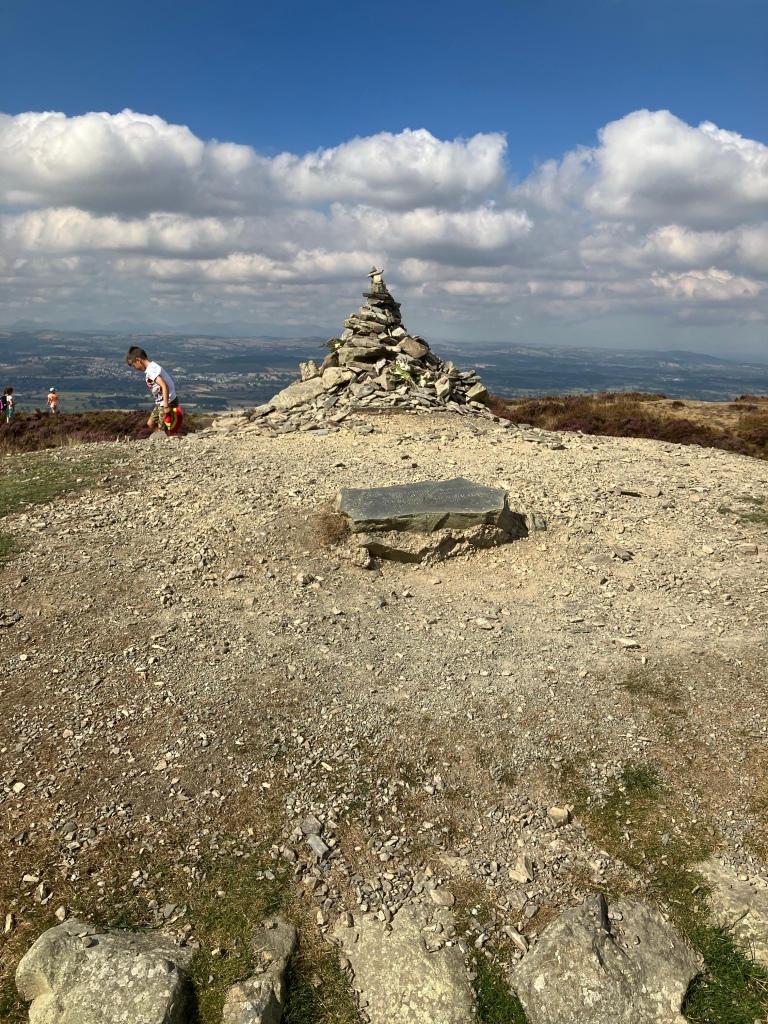
It took me a little over two hours to rise from 32 metres elevation at Bodfari to 440 metres elevation at the summit of Penycloddiau. A relentless slog. As I crested the summit, I expected solitude, or maybe a couple of hardy hill walkers sharing a flask of tea. But what I didn’t expect was a young mum in a summer frock and sandals, with three young children playing on the cairn.

So, there’s another way up. Sure enough, the map shows a car park right on the trail, about 2 km west of here.

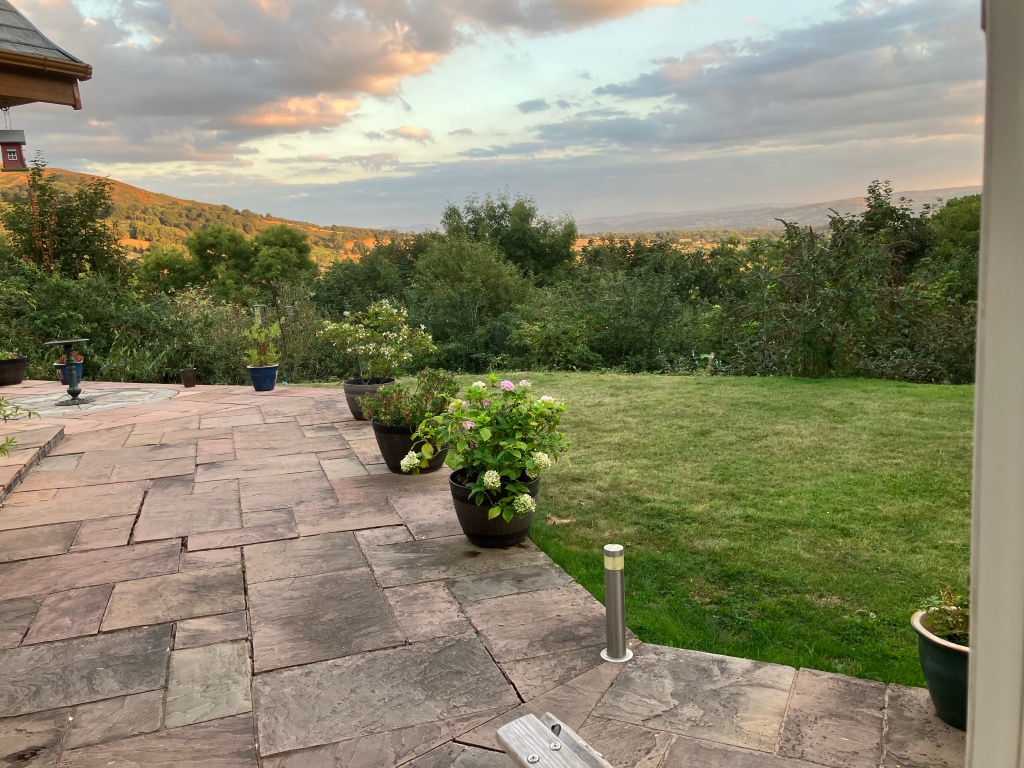
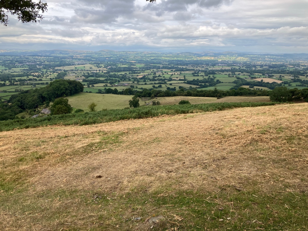
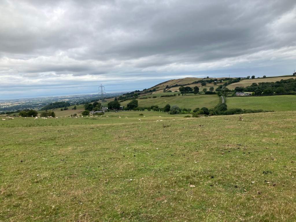
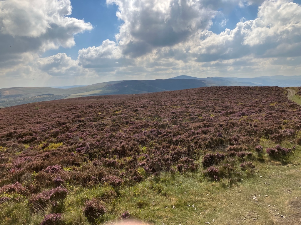
The view fom the top is outstanding. A full 360 degree panorama

I walked on, meeting a dozen or so people on the way (very busy) and met Doris from Switzerland. Doris knows these hills very well and was able to provide much good advice

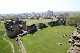
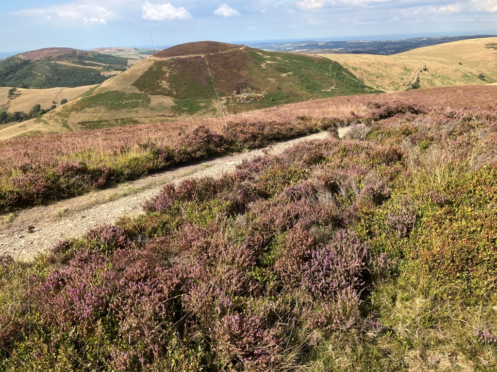
Apart from the fearsome inclines, the next point of interest is Moel Arthur. King Arthur’s hill fort

I’m not sure if Lancelot and Guinnivere et al actually lived here but that’s the story

I stopped for lunch by the cattle grid and stared in awe at the next stretch of Offa’s Dyke Path. This path looks to be near vertical. But it is the marked pathway so I reasoned that I had to take it. Talk about ‘a bit of a scramble’! I went the final 100 metres literally on my hands and knees, pulling myself along by grabbing clumps of vegetation. Jubilee Tower is visible from here

Pretty well a 3 km ridge walk from here.

If you’d like to contribute to Parkinson’s UK, here’s the link

https://www.justgiving.com/fundraising/sebastians-swagger

Bodfari, then, is it?

Is the world becoming a more caring place or have I just had a series of decent people running our transport today?

It all started with the 08:23 Bexley train running 22 minutes late. The train driver came on the tannoy on four separate occasions to apologise for “any inconvenience this may have caused you”. He apologised another three times for being stuck on a red signal for 10 minutes just outside London Bridge because we had ‘missed our slot’. And you know what? I really think he meant it.

Down on the Northern line there was a railway lady urging ‘customers’ not to fret and there would be another train along in a minute. And there was. And it wasn’t busy. Everyone got a seat.

On the Avanti big train the poor buffet lady in Carriage C had no coffee until supplies could be replenished at Preston. Makes no odds to me, I don’t drink coffee but she was heartbroken and peppered every announcement with apologies about the coffee (or lack of it ☹️)

The conductor on the Welsh diesel out of Crewe was clearly very happy in his work. He called everyone ’Man’,’Dude’ or ‘Darling’ as he checked their tickets and was very bjg on the mic (Yesindeedee) as we came into Chester.

And my two bus drivers today have been magnificent. The first one waited for me to run up a crowded street, wobbling with my top-heavy rucksack. He then unraveled my incoherent mumblings and presented me with a ticket to where I needed to go, even though I didn’t know where that was myself.

The last bus driver brought me to Bodfari. He held everyone up whilst he reprinted my ticket to save me 30p. He then dropped everyone home, one at a time, seemingly irrespective of whether they had a bus stop near by or not. He stopped to pick up two young boys after football and dropped them off at the bottom of the hill. You don’t get that in London!

What a very nice man. I gave him a sticker

I stayed last night with Ian Priestley, who has a very nice B&B in Bodfari (07957 366151). He built the place himself and it has the most amazing views

If you’d like to make a contribution to Parkinson’s UK, here’s the link:

https://www.justgiving.com/fundraising/sebastians-swagger

So here I sit. In Bodfari. Ready for tomorrow’s assault on the hills of Clwyd.

Distanceometer

As at 30th August 2022

The distanceometer has been calculating how far we’ve traveled so far and it looks like 352 km (or almost 10% of the total planned.

I had hoped to reach Lands End this year but that’s looking like next year now. I’m setting my sights on Weston Super Mare now

I’ll be back to Bodfari later today and this leg should get me to Welshpool by next Tuesday. I plan to update this blog daily, for the next eight days

Bodfari to the Jubilee Tower ( #1)

Ditance: 5.7 km

Steps: 8,992

Why #1 ?

Because later this week, there will be a #2

I went to Morrisons and stocked up with two days food and water

I loaded this into my rucksack together all of my regular (minimal) kit

I set off at 8:30am with a spring in my step

But I’d only gone a tad over 1 km (not even got to a proper hill yet) when I came to realise that this route, me, and this pack were incompatible. I have made a tactical withdrawal and I will return by next weekend with a much better plan and more appropriate kit

The Bashette

My latest homespun creation is just a step away from a bivvy bag. I really don’t like bivvy bags. With the hood down you can just about guarantee rain, so both you and your sleeping bag are going to get wet. With the hood up, the clammy bag is resting on your face and you’re re-breathing secondhand air.

My lovely wife has made me a 1.5 metre square tarp of waterproofed rip-stop nylon, eyelets all round. With this tarp strung up above my head and shoulders, I can now sleep in a bivvy bag with the hood down and not get wet. We call it a bashette.

Total weight (bivvy bag, bashette, tent pegs, cordage and stuff sack) 940 grams

There are no poles. You have to improvise

I slept in it last night. It rained. I stayed comfy and dry.

It’s a bugger to get into but works just fine once you’re in

If you’d like to contribute to Parkinson’s UK, please click the link below. Thank you

https://www.justgiving.com/fundraising/sebastians-/swagger

Day 26 – Rhuualt to Bodfari

Ditsnce: 16.4 km

Stepps: 28,992


I was away from the White House by 6:00 am. I had intended to stop for breakfast but the first member of staff to arrive advised me that chef needed all breakfast orders the preceding night. I didn’t fancy sticking around for the argument, so I hit the road

A casual glance at the map/guidebook shows the Offa’s Dyke Path crossing the busy A55 Rhuualt by pass and heading off south-east but that’s not right. The actual path goes east for 400 metres to cross the A55 via a high level footbridge. This is a bit of an uphill slog but saves dicing with death in the traffic. It is uphill all the way, plus a flight of steps to finally reach the bridge

Half a km on and I encountered my first clearly recognisable section of Offa‘s Dyke (at grid ref. 080746). Thought provoking. I wonder what will be left of this civilisation in 1,200 yeas. Perhaps railway embankments might be incorrectly identified as defensive structures ?

As I ascended the steep gradient to Moel Maenefa, I stopped to talk awhile with a lady coming the other way. She was surprised that I had no poles and offered me hers (as a gift) saying “You’re going to need them where you’re going!” How kind 🙂

There’s a particularly well sited bench at the top of this hill. Not only is it just in time to rest your legs after the ascent but it also provides a magnificent view back over Rhyl to the sea

There are a few more gentle undulations but for today at least, the path maintains an elevation of around 250 to 300 metres

That is of course until you descend down into Bodfari (elevation 32 metres) and give up all of that hard-won height

There are however consolations: This stream, on the way down, is inhabited by all manner of monstrous ceeatures. There’s a first class pub in Bodfari which does excellent food. And best of all, the Bodfari campsite, owned by a lovely lady called Jan, where you can get a hot shower and rest your weary legs. It’s a good idea to book ahead (07745 944102). Thanks for your contribution Jan 👍

If you’d like to make a donation to Parkinson’s UK, please click below

Day 25 – Prestatyn to Rhuualt

Distance: 23.9k

Steps: 33,811

With my trusty map and compass safely stowed in my rucksack, I set out ‘Trailblazer’ guide in hand. The first bit is straightforward. From the rock, head for the railway footbridge, over this and straight up the High Street. So far, so good. I reach the discarded helmet of an ancient legionnaire

I have left my rucksack in the picture to provide perspective on the size of this helmet. Proof if ever such were needed, that thousands of years ago, giants did in fact roam this planet. I met a man sitting up by the giant helmet. He was there for a smoke and he had a sniffly nose.

The guide book said (somewhat ambiguously) to go on up through Hillside Gardens, which I did, and in the absence of any bearing to go on, I followed the most major track or path. I came upon a fabulous viewpoint, then Gwaenysgor village and the Eagle & Child pub.

By which time I was sure that I was off the guidebook route. I’d strayed half a km to the east. I could see a series of footpaths on the map, that would put me back on the trail. En route I’d gathered a 2-year black Labrador (Poppy?).

I was throwing her slimy ball and she loved to bring it back. Her rightful owner is Peter, a walker too, and he gave me some good local footpath information. Thank you.

No sooner was I back on the proper path, I was overtaken by Matt, a North Wales long distance runner, in the lead of a field of eighteen runners in a 200 mile race. I met more of these heroic athletes as they all passed me throughout the day

At Trelawnyd I found this remarkable old mill wheel mechanical contraption thingy. It is way beyond repair but it clearly was a miracle of engineering in its day. The photo doesn’t do it justice.

I arrived at the (rather posh) White House in Rhuualt just after 7:00pm, very weary. I had intended to get a bite to eat then move on and wild camp further along the trail but they kindly found me a pitch and let me stay. So I undid my boots and settled down to a proper meal.

Totally different kind of camping. My ‘pitch’ measured 12 metres x 4 metres and came with electric hook-up and running water. I slept in the centrally heated shower block and was gone by 6:00am.

Lovely people though!

If you’d like to donate to the Parkinson’s UK charity appeal, please click the link below:

https://www.justgiving.com/fundraising/sebastians-swagger

Flint, Prestatyn and Rhyl

Distance: 17.7 km

Steps: 30,418

David had to be at work for 8:45 am. He left me at Flint Castle, where I sat on a bench looking at Wallasey Island across the River Dee estuary and brought my blog up to date. It was a crisp clear morning and I reckoned I could pick out Heswall

Tomorrow I start on the Offa’s Dyke Path section of this ECP trail. It’s a different undertaking in three distinct ways:

  1. For the first time in all of my recent travels I’m going to try to walk from a guide book, rather than map and compass. It looks easy enough. I have a very detailed ‘Trailblazer’ guide. I got this from Ordnance Survey and it covers the entire route of the Offa’s Dyke Path strarting either from the north or south
  2. It’s ‘Hill Walking’ rather than ‘Coastal Walking’ so a bit more up and down, and much further off grid. Apart from a few ‘free range eggs/fresh fruit/honesty boxes at the roadside, I don’t expect to find many shops the way that I’m going. So I’ll be carrying more food and water than usual
  3. I have no accommodation booked. I intend to camp or wild camp most of this section. This will be a much more pleasant undertaking if the weather is on my side. The forecast is encouraging but I have little confidence in the Met Office

Flint Castle was built by English king Edward I in about 1280 as part of his strategy to keep control of Wales and the Welsh people. It is a very peaceful place now but has not always been so.

I walked back to the railway station, where station staff were carrying out a bit of a blitz on fare-dodgers. I chatted with the lady in charge, who had just last week been on holiday to Ramsgate and Whitstable. Nobody could throw any light on this huge mechanical foot, glimpsed from the station bridge.

So I did a bit of research myself. It’s called ‘Footplate’ by Brian Fell and celebrates the many cycle routes that start/finish at Flint. It stands 3 metres tall and has been there since 1999.

I got the 10:13 train, one stop, six minutes, to Prestatyn (so I did, and she hit me).

The town of Prestatyn has grown much bigger in the past thirty years but I headed away from this, towards Pontins and the beach.

Pontins is about as scruffy as it gets but once something special happened under that blue roof involving Frankie Beverly & Maze
This rock, on the seafront north of Prestatyn town, commemorates the spot where the Offa’s Dyke Path meets the sea at its northern end.
My starting point for tomorrow

With my toes in the sand, I stopped for a beer and a sandwich, then walked into town to send a couple of postcards and to stock up on water and provisions for tomorrow’s journey

I caught the next train to Rhyl.

For some reason I thought that Rhyl was a quaint little seaside town. How wrong can one be? It rivals Blackpool for noisy nightlife and attracts young people in their thousands. There’s a proper ‘strip’, a water park (slides) and a whole parade of amusement arcades. The seafront area boasts about three miles of sandy beaches and (what is it with these NW resorts?) the tide goes out for miles. There is a bus station and a train station. I took some photographs for Gill.

I set out early the next morning to return to Prestatyn and the start of Offa’s Dyke Path. I just couldn’t resist a picture of these crocheted ‘Gatepost Covers’. I’ve seen similar in trees on the Isle of Wight

To donate to Parkinson’s UK, click the green link below:

https://www.justgiving.com/fundraising/sebastians-swagger

The Duke of Lancaster

Distance: 18.2 km

Steps: 32,455

The last time I saw this ship it was painted entirely in white and was decorated with some very good grafitti but it has now been returnd to original livery together with much additonal rust

The old Duke of Lancaster is visible on he skyline for miles around. We always used to know that we were almost there when we saw the ship

Whilst I am eternally grateful to Anthony at the Yacht for his kind hospitality, a concrete floor is a challenging place to sleep. So it was that I was awake early this morning and on the trail into Flint by 6:00am. There is a very nice castle , though it looks a bit beaten up. It looks as if the last time it did its job in anger, the other side had some serious ordnance

I sat admiring the view across the River Dee to Wallasey Island. Jack and I were there last week. I must have dozed off (nothing unusual there) because next I knew, a ‘Snap-on Tools’ man had walked over from the car park, 200 metres away, to make sure I was OK

I followed the Wales Coast Path for another km, then wedged myself in amongst some rocks and went to sleep. I was woken up by David

David follows the principles of Islam, he carried my heavy bag, made me breakfast at his place of work, made me an evening meal and gave me a place to sleep in his home. A very kind man

There’s more to tell ..

I left my wardrobe, basher and sleeping bag at David’s factory for later collection. Refreshed and with a lighter bag, I strode out for Mostyn and the Duke of Lancaster

Mostyn

If you’d like to donate to the Parkinson’s UK charity appeal, please click the link below:

https://www.justgiving.com/fundraising/sebastians-swagger

Day 24 – Shotton to Flint

Distance: 11.3 km

Steps: 20,167

Planned engineering work has shut London Bridge and all points up-line, so went via Victoria. Which was oK 👍

Arrived at Euston in good time and on Jack’s behalf I went looking for the Euston arch. Nearest I found to it was this pub sign. The pub is real enough but there’s a buildig site where the arch would have been

Today was a stifling hot travelling day on the busiest trains I have ever seen. The drivers’ industrial action has certainly screwed things up

Most of the reserved seats were double boooked and there were people in the luggage racks. I had a reservation, seat F-04 but so did another lady. Luckily she liked House music and is going to Ibiza next week we shared the seat and got on well.

I never bothered going on to Hawarden but hit the trail as soon as I reached Shotton. It is much nicer.

There’s a tidal estuary running around the back of the shops. I met a romanian guy out unsuccessfully trying to catch his supper whilst his wife provided a constant running commentary in her own language

‘The Rock’ is the name given to the largest cable stayed assymetric bridge in the UK. Opened by the queen in 1998, it carries the busy A548 over the River Dee

These four chimneys are deceptively tall, over 100 metres but are built on lower ground wih a motorway embankment in front of them which reduces the impact. They belong to Connah Quays power station. Only three are ever in use at once, wih one turbine always in reserve

I walked on towards Flint and was encouraged by the regulars of The Yacht to stop for a pint (didn’t really take very much encouragement). A right nice crowd. Thank you Simon for your donation and thanks to guv’nor Anthony for your hospitality 👍

Day 023 – Heswall to Hawarden

Distance: 11.1.km

Steps: 18,867

A short day today. I think it was the hottest day of the year. Jack is back in London and I set out in the heat already before 9:00am. I initially thought that Heswall was a small village kind of place and so it is. The village is built on the side of quite a steep hill with nice views to Wales, over the Dee estuary. In this part of Heswall there’s not a straight road to be found. The roads twist and turn and somewhere in the midst of this I found a little parade of village shops. There are lots of big old houses behind high stone walls and solid gates. Quaint.

But Heswall has another side to it altogether. At the top of the hill is a busy high street with a railway station, a coach station, Marks & Spencer, a proper branch of Lloyds bank, Wetherspoons and a few dozen healthy looking shops. Best of both worlds

The Wirral Way continues on its course south of the village so I followed this towards Neston, back on the nice level dismantled railway. This has a bit more elevation than the shoreline and gaps in the right hand hedge reveal tantalising glimpses of the North Wales coast across the River Dee estuary.

I walked as far as Neston and paused for refreshments. I was faced with a small dilemma: Either to commit to a 15 km walk to Hawarden on this very hot day (with no optional/alternative route, no buses, no railway station and no villages along the way) or to go one stop to Hawarden on the train and have an early bath. I took the train.

And arrived back in London (via Chester and Crewe) at 7:00pm. I’ll be travelling back to Hawarden to continue the England Coast Path next Sunday, having re-provisioned and changed my socks. Next leg is Offa’s Dyke (1, 2 and 3) Prestatyn to Chepstow (probably via Rhyll). Watch this space.